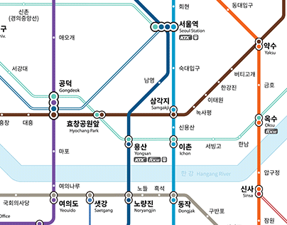
The Seoul Metro map changed after 40 years.
The Seoul Metro map was developed to be easy to read for everyone, including color-blind and impaired people and foreigners. By centering on the Line 2 Loop Line, which applies the international octolinear standard, and a circular shape, users can easily and efficiently find their way around, and the transfer stations, which are mixed in the same form with regular stations, have been improved by using the traffic light method. In addition, major geographical information such as the Yellow Sea and Hangang Rivers are also displayed so that tourists can understand their current location as a bearing, and colors and patterns that are easy to distinguish between routes are applied to make it easier for the color-blind, and elderly to see.
The post originally appeared on following source : Source link
Seoul Metro Map (Official)
135
previous post

